Articles: Adoranten 2011
Gobustan - Rock Art Cultural Landscape, by Malahat Farajova
 Located in the eastern part of the Republic of Azerbaijan and on the western shore of
the Caspian Sea Gobustan National Reserve was inscribed as Gobustan Rock Art Cultural
Landscape into the World Heritage List in 2007.
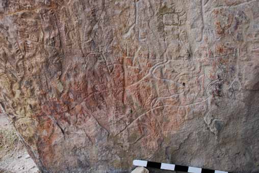
With hills and highlands covered with big boulders and almost no green, Gobustan is an
outstanding rock art landscape, where over 6000 rock engravings were found and registered,
since Upper Palaeolithic up to the Middle Ages. In 1966, the rock art area, covering
approximately 4000 hectares, was declared a National preserve.
Read the article as pdf
Located in the eastern part of the Republic of Azerbaijan and on the western shore of
the Caspian Sea Gobustan National Reserve was inscribed as Gobustan Rock Art Cultural
Landscape into the World Heritage List in 2007.
With hills and highlands covered with big boulders and almost no green, Gobustan is an
outstanding rock art landscape, where over 6000 rock engravings were found and registered,
since Upper Palaeolithic up to the Middle Ages. In 1966, the rock art area, covering
approximately 4000 hectares, was declared a National preserve.
Read the article as pdfHorg, hov and ve – a pre-Christian cult place at Ranheim in Trøndelag, Norway, in the 4rd – 10th centuries AD, by Preben Rønne
 In the summer of 2010 a well-preserved cult place was excavated at Ranheim on Trondheim Fjord, in the county of Sør-Trøndelag, Norway. The site consisted of a horg in the form of a flat, roughly circular stone cairn c.15 m in diameter and just under 1 m high, a hov in the form of an almost rectangular building with strong foundations, and a processional avenue marked by two stone rows. The horg is presumed to be later than c. AD 400. The dating of the hov is AD 895–990 or later, during a period when several Norwegian kings reigned, including Harald Hårfager (AD 872–933), and when large numbers of Norwegians emigrated and colonized Iceland and other North Atlantic islands between AD 874 and AD 930 in response to his ruthless regime. The posts belonging to the hov at Ranheim had been pulled out and all of the
wood removed, and the horg had been carefully covered with stones and clay. Thereafter, the cult place had been entirely covered with earth, presumably during the time of transition to Christianity, and was thus effectively concealed and forgotten until it was excavated in 2010.
Read article as pdf
In the summer of 2010 a well-preserved cult place was excavated at Ranheim on Trondheim Fjord, in the county of Sør-Trøndelag, Norway. The site consisted of a horg in the form of a flat, roughly circular stone cairn c.15 m in diameter and just under 1 m high, a hov in the form of an almost rectangular building with strong foundations, and a processional avenue marked by two stone rows. The horg is presumed to be later than c. AD 400. The dating of the hov is AD 895–990 or later, during a period when several Norwegian kings reigned, including Harald Hårfager (AD 872–933), and when large numbers of Norwegians emigrated and colonized Iceland and other North Atlantic islands between AD 874 and AD 930 in response to his ruthless regime. The posts belonging to the hov at Ranheim had been pulled out and all of the
wood removed, and the horg had been carefully covered with stones and clay. Thereafter, the cult place had been entirely covered with earth, presumably during the time of transition to Christianity, and was thus effectively concealed and forgotten until it was excavated in 2010.
Read article as pdfLascaux - The history of the discovery of an outstanding decorated cave by Muriel Mauriac
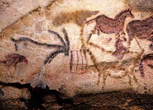
 The casual discovery of Lascaux cave by four teenagers, Marcel Ravidat, Jacques Marsal,
Simon Coencas and Georges Agniel in September 12, 1940, during troubled time, have
changed the perception of modern man about prehistoric times. This discovery, immediately
considered as a major event, offered the world a cave free of any exploration, arousing the
enthusiasm of the international scientific community but also of the general public. However, its opening to the public and the incredible excitement it generated, rapidly
destabilized its fragile natural environment. From crisis to solutions, Lascaux will be a place of many experiments that have willy-nilly turned it into a laboratory for the conservation of decorated caves. Thus the story of its preservation will greatly improve our knowledge about these complex environments
Read the article as pdf
The casual discovery of Lascaux cave by four teenagers, Marcel Ravidat, Jacques Marsal,
Simon Coencas and Georges Agniel in September 12, 1940, during troubled time, have
changed the perception of modern man about prehistoric times. This discovery, immediately
considered as a major event, offered the world a cave free of any exploration, arousing the
enthusiasm of the international scientific community but also of the general public. However, its opening to the public and the incredible excitement it generated, rapidly
destabilized its fragile natural environment. From crisis to solutions, Lascaux will be a place of many experiments that have willy-nilly turned it into a laboratory for the conservation of decorated caves. Thus the story of its preservation will greatly improve our knowledge about these complex environments
Read the article as pdfRock Art of Tamgaly, Kazakhstan by Luc Hermann
 Central Asia offers a large number of rock art sites with similarities in chronology, techniques
and iconography, both in Uzbekistan (Sarmishsai), in Kyrgyzstan (Saimaluu-Tash, Cholpon-Ata) and in Kazakhstan.
In Kazakhstan, the main sites are located in the south, especially between the Karatau Mountain range (Arpauzen) and the Chinese border (Eshkiolmes, Bayan Zhurek, Usek). In the centre of this area, which is as wide as Italy, there are two important sites: Kulzhabasy, with approximately 4000 engravings and, 50 km to the east, Tamgaly with around 5000 petroglyphs.
The site of Tamgaly, located 125 km northwest of Almaty, was discovered in 1957 by Anna Maksimova (1923-2002). In the following years, she researched the rock engravings with Alexei Maryashev and Antonina Ermolayeva, while archaeological excavations were later led by Alexei Rogozhinsky.
In 2004, Tamgaly was listed as a World Heritage site by virtue of “the dense and coherent group of petroglyphs, with sacred images, altars and cult areas, together with their associated settlements and burial sites (which) provide a substantial testimony to the lives
and beliefs of pastoral peoples of the Central Asian steppes from the Bronze Age to the present day” (Unesco).
Read articleas pdf
Central Asia offers a large number of rock art sites with similarities in chronology, techniques
and iconography, both in Uzbekistan (Sarmishsai), in Kyrgyzstan (Saimaluu-Tash, Cholpon-Ata) and in Kazakhstan.
In Kazakhstan, the main sites are located in the south, especially between the Karatau Mountain range (Arpauzen) and the Chinese border (Eshkiolmes, Bayan Zhurek, Usek). In the centre of this area, which is as wide as Italy, there are two important sites: Kulzhabasy, with approximately 4000 engravings and, 50 km to the east, Tamgaly with around 5000 petroglyphs.
The site of Tamgaly, located 125 km northwest of Almaty, was discovered in 1957 by Anna Maksimova (1923-2002). In the following years, she researched the rock engravings with Alexei Maryashev and Antonina Ermolayeva, while archaeological excavations were later led by Alexei Rogozhinsky.
In 2004, Tamgaly was listed as a World Heritage site by virtue of “the dense and coherent group of petroglyphs, with sacred images, altars and cult areas, together with their associated settlements and burial sites (which) provide a substantial testimony to the lives
and beliefs of pastoral peoples of the Central Asian steppes from the Bronze Age to the present day” (Unesco).
Read articleas pdfShip Engravings in Armenia? by Luc Hermann
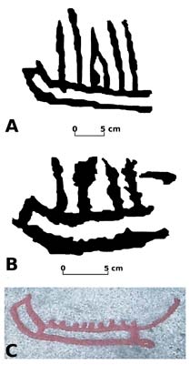
 During an expedition in October 2011 in the Syunik province of Armenia, the Institut für
archäologische Denkmalforschung (Austria) documented rock art on the slopes of the
Ughtasar Mountain. The Ughtasar is an extinct volcano located 20 km north of Sisian, whose rock art was discovered in 1966 and partially published in 1970 by Karakhanian and Safian. Many important panels remained undocumented, and no further publications have appeared
on the Ughtasar rock art to the present day. We focused our research around a small crater lake situated at 3270 m a.s.l. in a five hectares area where we found approximately 100 carved rocks.
Read article as pdf

|

